Data planning resources

The foundation to evaluating land use decisions is information. Planners, municipalities and other stakeholders interesting in land use planning rely on data to complete or implement land use or regional plans.

Here are sources of data from Alberta that are useful for land use and data planning. Select a category to refine the land use datasets by topic.

If there is an Alberta dataset not on the list, contact us to submit any relevant data or map.

Interactive Environmental Indicators

Interactive Environmental Indicators

Alberta Municipal Data Sharing Partnership

Alberta Municipal Data Sharing Partnership

Strathcona County

Strathcona County

Town of Canmore Open Data

Town of Canmore Open Data

Town of Cochrane Open Data

Town of Cochrane Open Data

Airdrie

Airdrie

City of Medicine Hat

City of Medicine Hat

Benchmark Retrieval System

Benchmark Retrieval System

St. Albert Data

St. Albert Data

Heating Degree Days

Heating Degree Days

City of Red Deer Data

City of Red Deer Data

City of Lethbridge Data

City of Lethbridge Data

City of Grande Prairie Data

City of Grande Prairie Data

Town of Banff Data

Town of Banff Data

City of Calgary Datasets

City of Calgary Datasets

Electric Vehicle Charging Stations

Electric Vehicle Charging Stations

Environmental Insights Explorer

Environmental Insights Explorer

City of Edmonton Data

City of Edmonton Data

Regional Aquatics Monitoring Program

Regional Aquatics Monitoring Program

AQUASTAT

AQUASTAT

Energy Dashboard

Energy Dashboard

RADARSAT Imagery

RADARSAT Imagery

Alberta’s Wild Spaces

Alberta’s Wild Spaces

Power lines and Access Roads

Power lines and Access Roads

Alberta Water Nexus Simulation

Alberta Water Nexus Simulation

FireWork Smoke Prediction System

FireWork Smoke Prediction System

Invasive Species Map

Invasive Species Map

Weather Forecast for Fire Predictions

Weather Forecast for Fire Predictions

Geoscience Data

Geoscience Data

Air Pollution Map

Air Pollution Map

Historical Watershed Maps

Historical Watershed Maps

Irrigation District Water Quality

Irrigation District Water Quality

Canadian Disaster Database

Canadian Disaster Database

Seismic Events

Seismic Events

Dam and Pond Map

Dam and Pond Map

Pipelines Map

Pipelines Map

Watershed Reports

Watershed Reports

Groundwater Observation Well Network

Groundwater Observation Well Network

Flood Hazard Map

Flood Hazard Map

Water Licenses

Water Licenses

Farmers’ Markets

Farmers’ Markets

Local Food Asset Map

Local Food Asset Map

Alberta Major Projects

Alberta Major Projects

Broadband Coverage

Broadband Coverage

Agriculture Census

Agriculture Census

Alberta’s Energy Profile

Alberta’s Energy Profile

Smoke Forecasts

Smoke Forecasts

Geothermal Feasibility Maps

Geothermal Feasibility Maps

Alberta Electric Generation

Alberta Electric Generation

Alberta Water Tool

Alberta Water Tool

Energy Reserves and Outlook

Energy Reserves and Outlook

Wind Power Forecasting

Wind Power Forecasting

Photovoltaic and Solar Potential

Photovoltaic and Solar Potential

Monthly Drilling Activity

Monthly Drilling Activity

Coal Mine Atlas

Coal Mine Atlas

Alberta Climate Records

Alberta Climate Records

Freshwater in Glaciers and Icefields

Freshwater in Glaciers and Icefields

Lake Bathymetry Data

Lake Bathymetry Data

Aquifer Vulnerability Index

Aquifer Vulnerability Index

Alberta’s Species at Risk

Alberta’s Species at Risk

Alberta Soil Information Centre

Alberta Soil Information Centre

Alberta Climate Information Service

Alberta Climate Information Service

Climate Atlas

Climate Atlas

Drought Monitor

Drought Monitor

Climate Data and Simulations

Climate Data and Simulations

Fish Sustainability Index

Fish Sustainability Index

Protected Areas, Crown Land and Environmentally Significant Areas

Protected Areas, Crown Land and Environmentally Significant Areas

Forest Statistical Data

Forest Statistical Data

Forest and Vegetation Inventory

Forest and Vegetation Inventory

Wildfire Data

Wildfire Data

River Water Quality Index

River Water Quality Index

Recreational Access to Agricultural Public Lands

Recreational Access to Agricultural Public Lands

Geological Datasets

Geological Datasets

Open Data Areas Alberta

Open Data Areas Alberta

Human Footprint Inventory

Human Footprint Inventory

Landscape Analysis Tool

Landscape Analysis Tool

Agricultural Land Resource Atlas of Alberta

Agricultural Land Resource Atlas of Alberta

Regional Dashboard

Regional Dashboard

Economic Dashboard

Economic Dashboard

Economic Statistics

Economic Statistics

Provincial Electoral Divisions

Provincial Electoral Divisions

Geospatial Statistics

Geospatial Statistics

Air Data Warehouse

Air Data Warehouse

Population Statistics

Population Statistics

Alberta Tomorrow

Alberta Tomorrow

Community Growth Simulator

Community Growth Simulator

Historical Landuse

Historical Landuse

Fisheries & Wildlife Management Information System

Fisheries & Wildlife Management Information System

Conservation Information System

Conservation Information System

Wetland Inventory

Wetland Inventory

Base and Property Maps

Base and Property Maps

Water Well Information

Water Well Information

Alberta River Basins

Alberta River Basins

Species and Habitat Data

Species and Habitat Data

ABMI Map Portal

ABMI Map Portal

Biodiversity Browser

Biodiversity Browser

Municipal open datasets in Alberta

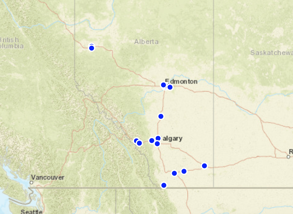
The City of Grande Prairie has compiled all the open data portals from municipalities in Alberta onto a single map. Use the interactive map to explore the available open datasets from across the province.

Map of open data portals in Alberta

See the Alberta Open Data Portals Map

Submit info on Alberta data planning

Send us any relevant datasets, interactive map or data that should be included in our collection of Alberta land use datasets.

Submit an Alberta land use dataset

Subscribe To Our Newsletter

Subscribe To Our Newsletter

Join our mailing list to receive monthly news and updates from the Land-use Knowledge Network.

Thanks! You have successfully subscribed.

Subscribe To Our Newsletter

Subscribe To Our Newsletter

Join our mailing list to receive monthly news and updates from the Land-use Knowledge Network.

Thanks! You have successfully subscribed.